Google Maps Updates

  • Thread starter Thread starter powdermonkey
  • Start date Start date
  • Replies Replies 1,206
  • Views Views 260,286

Source

Google Earth allows people to explore the world, from big cities to remote countrysides. For Peter Welch, it’s a window back in time, helping him discover centuries of history hidden beneath the surface of English farmlands.
 
Official Google India Blog: Stay informed about local bus and long-distance train schedules, now on Google Maps

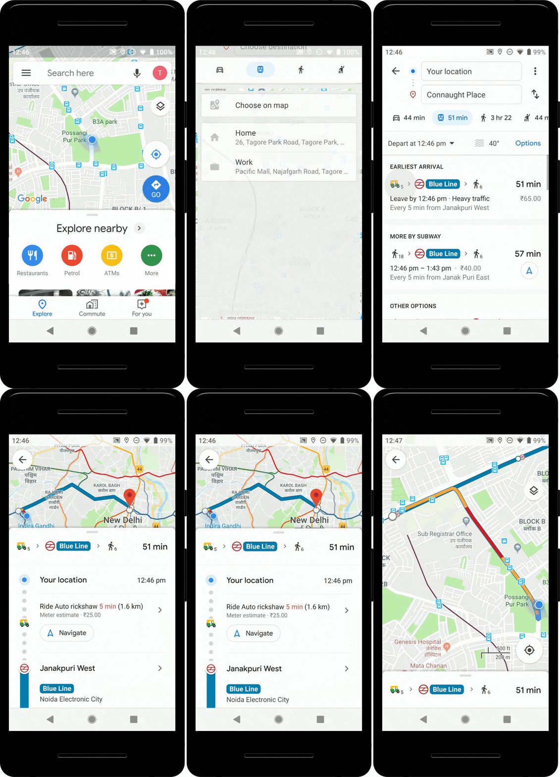
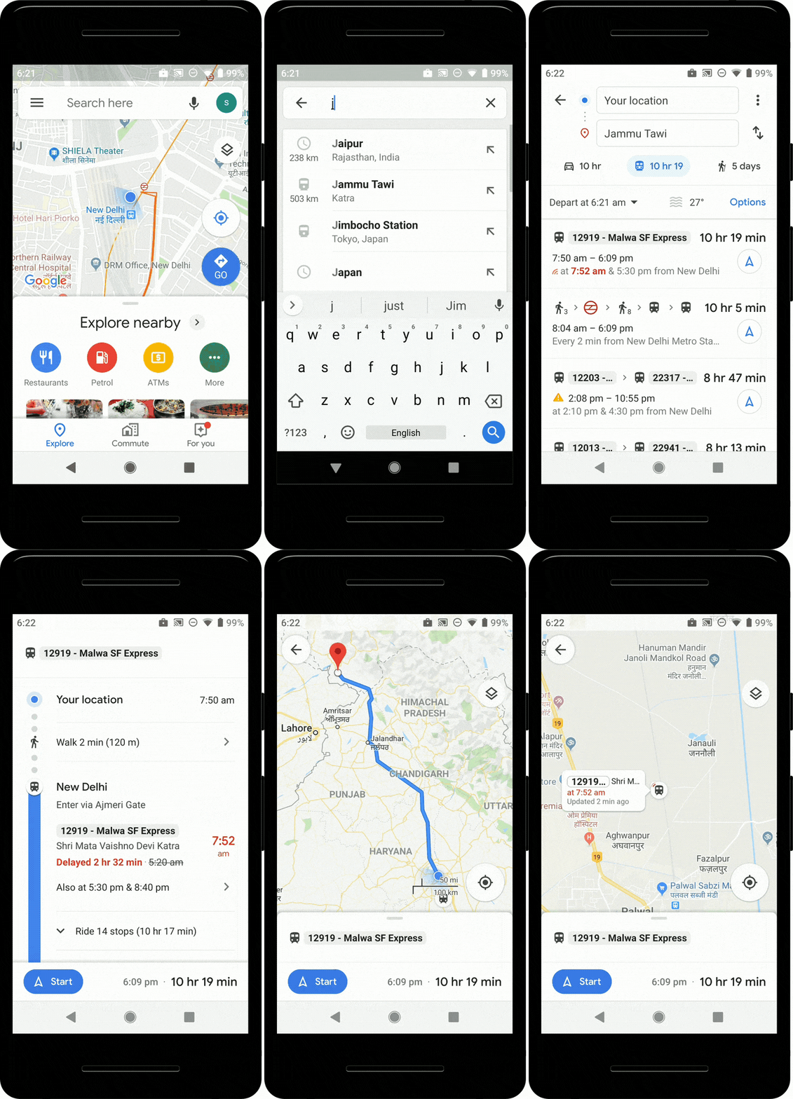
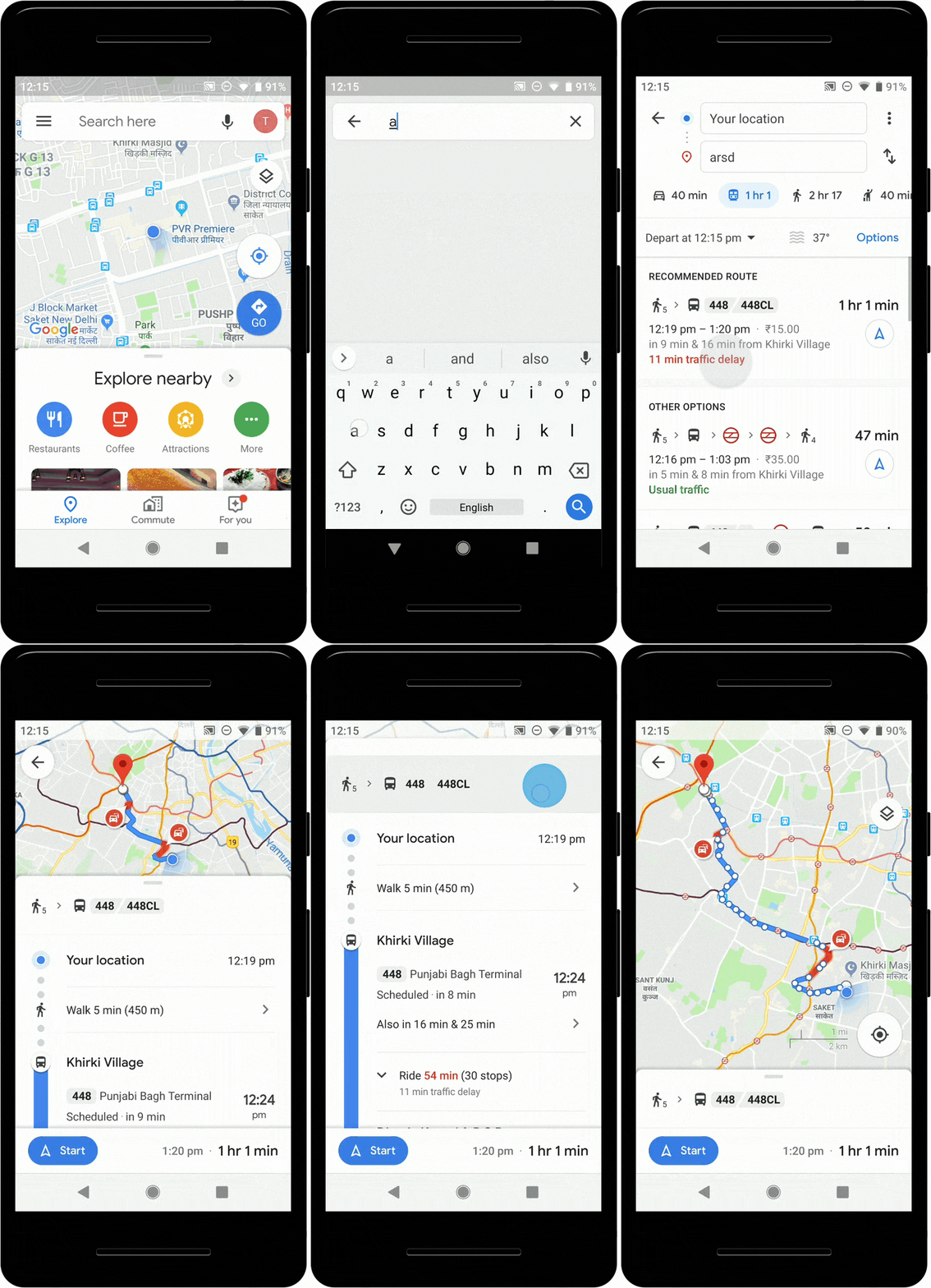
Today we are happy to announce three more features to Google Maps in India, to make public transport journeys more efficient and seamless: Bus travel times from live traffic in 10 of the largest cities in India, live train status for Indian Railways trains, and mixed-mode commute suggestions that now combine auto-rickshaw and public transport.
Google Maps can now tell you about your bus travel times based on live traffic. This uses the power of Google’s live traffic data and public bus schedules to calculate delays and provide accurate travel times. This is the first product of its kind -- launching first in India -- enabling you to know how long your bus trip will take when factoring in live traffic conditions. This feature is launching in Delhi, Bangalore, Mumbai, Hyderabad, Pune, Lucknow, Chennai, Mysore, Coimbatore, and Surat.
Google Maps can now help you know when your train will arrive by indicating the real-time status. Search for your starting location and destination, or your starting station and destination to see a list of trains that you can take between the routes. From there, you can easily see the real-time status, and whether any of them are delayed, right inside Google Maps. This feature was developed in partnership with the Where is My Train app that Google acquired last year.
We’re excited to announce directions support in Maps for journeys that combine auto-rickshaw and public transport. The public transport tab on Google Maps for Android will now tell you when taking such a journey is a good option, how long it will take, which station you should take an auto-rickshaw to/from. You can also see the rickshaw meter estimate, and departure times for your transit connection. This feature will be available for Delhi and Bangalore initially and will soon be extended to more cities.

Cc2gGnS.gif
VRIPywt.gif
pXNlY7a.gif
 
Bringing slave dwellings out of the shadows with Google Street View


Source

In the Virginia state record, only 1% of documented historical sites are categorized as having any African-American historical significance. It’s easy to visit historic sites from the era of slavery and forget the enslaved men, women and children who built and maintained these places. Using Street View, Virginia Humanities has been collecting panoramic imagery of slave dwellings across the state for everyone to see. They hope these images will add to a more inclusive history of Virginia and helps us remember that enslaved peoples were integral to our country’s founding.
 
Grab a seat and be on time with new transit updates on Google Maps

To solve for this, Google Maps is launching live traffic delays for buses in places where we don’t already have real-time information direct from local transit agencies. You’ll now be able to see if your bus will be late, how long the delay will be, and more accurate travel times based on live traffic conditions along your route. You’ll also see exactly where the delays are on the map so you know what to expect before you even hop on your bus.

There’s nothing more uncomfortable than being packed like a can of sardines on a hot, sweaty train. We’re introducing transit crowdedness predictions so you can see how crowded your bus, train or subway is likely to be based on past rides. Now you can make an informed decision about whether or not you want to squeeze on, or wait a few more minutes for a vehicle where you’re more likely to snag a seat.
 
Back